Lake Assal
Lake Assal (Wiki entry) is located in one of the hottest areas on Earth. It is also the lowest point on the African continent, 155m below sea level. Water drains into the lake from the surrounding region, fed by runoff and underground springs (I'm making some of this up, but it sounds good.) With no place to drain to, the water evaporates in the sun and the water has become ten times saltier than the ocean!

You can see Lake Assal just west of the Gulf of Tadjoura.
To get to the lava field, our first objective, we drove west from Djibouti City, through the town of Arta, and turned north as we passed by the Ghoubbet El Kharab, which is a bay on the west end of the Gulf of Tadjoura. It was an awesome, scenic site, I'll post pictures of it later. A full description from divetours:
The Ghoubbet el Kharab or 'Devil's Cauldron' is surrounded by myth not unlike Loch Ness. Thought to be around 200m deep, it is almost cut off from the Gulf of Tadjourah by a narrow gully 750m long and as little as 100m wide in places. This almost circular sea is the very beginning of Africa's Great Rift Valley - the area between here and Lac Assal is considered one of the most remarkable - geographically speaking - in the world, as it marks the point of convergence between three continental plates in which the Arabian and African plates are gradually drifting apart. Volcanic activity could be one contributor to the title 'Devil's Cauldron', another could be the Afar legends of the monsters who inhabit its depths.
We turned away from the Devil's Cauldron and did some off-roading for a couple of miles. We paused at an automated geological station. The station had two seismic sensors, unusual for one of these stations as most have only one. This one had two for a good reason. Separated by only a few feet, nonetheless they were on different tectonic plates, one the African plate and the other the Arabic plate. A literal crack in the ground separated both plates and I easily straddled it, standing at once on Arabia and Africa (tectonically speaking.) In 1978, lava flows erupted in the area, indicating that the region was still alive (so maybe the volcanos are not as extinct as I thought...)
After a brief stop, we continued along the trail until it disappeared into a lava field. We hiked out to our first destination, one of several volcano cones poking out of the mesa. We climbed up to the first volcano and circled around up its cone. There was a deep crater in the center, hidden from view until we crested over the top. Looking down from the cone of the volcano, the ground fell away from it and went down towards Lake Assal. Another volcano was not too far away and we followed a bare trail to its peak. The crater inside this volcano was more accessible and we climbed down into it, after admiring the view of the lake from the top. As the day grew older, the sun grew hotter. Thankfully, we have been fully aclimatized and there was a strong wind, that while blowing hot, did cool us somewhat. We returned to our vehicles and proceeded to the next area.
We followed the hard ball road around the south end of the lake, pulling off the road prior to reaching the end. We walked a short distance, following a small stream until it ended in a cliff. At the base was a large, dark pool of water, cool to the touch. A small trickle of water flowed down a rock, feeding the stream. The stream itself was very hot to the touch! While a bit of water flowed down from the pool, the majority of the water entering the stream came out of the rocks. Another source was a small gurgling 'fountain' (for lack of a better term), which contained the hottest water of all! No one could keep their fingers in the 'fountain'. Of course, being Marines, we all had to stick our fingers in it to prove that it was hot (and that we could take it - peer pressure made everyone try it.) Then most of us had to try again just to make sure. Our index fingers all came out red from the heat.
Continuing our expedition, we drove on until we reached the lakeside where several rude huts clustered by the shore. About half a dozen pieces of earth moving equipment, for mining the salt I believe, were clustered around the huts. A series of rock tables were covered with various specimens of salt crystals and geodes, all for sale. We walked by the tables on our way to the lake. Once there we stripped down and went in. I was not prepared and did not bring any shower shoes, so I had to wear my running shoes into the lake. The reason why I did was because the lake bed was composed of solid salt, and it was very rough and sharp. The water was very warm, but still cool to the touch. As the water was so salty, everyone easily floated. It was amazing how high out of the water our bodies were suspended. The novelty quickly wore off as we could all feel the salt sticking to our body. We sloshed out to the shore where the water on our bodies quickly evaporated, leaving a thick, stickly residue of salt behind. The salt on my swim trunks quickly crystalized, leaving the shorts rough and inflexible, like it had been dipped in starch. We all rinsed off with the bottled water that we carried for this purpose, but I still had a lot in my hair and on my shorts. It was an uncomfortable ride home. I did purchase a couple examples of the crystalized salt and a geode from the locals.
Oh yeah, the Lake Assal region does not make a good training area. The lava rock covered ground is tough on boots and ankles, plus there are lots of cliffs and drop-offs that make night movements dangerous. So yes, some work was done on this trip, although the word 'boondoggle' was mentioned by some of my staff...
To the pictures...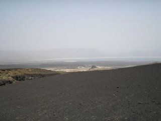
A far view of the lake from a lava field. You can see another volcano in the distance (we didn't climb that one!)
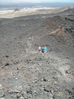 Looking down from the volcano cone, the next volcano cone can be seen as well as Lake Asal in the background.
 I stand on top of one cone. You can see the ground fall away to Lake Assal, 155m below sea level.
Not too many pictures of the Lake in this post as Blogger is acting up again, but more pictures will be posted soon!
DominicsDad, in Djibouti
posted by DominicsDad at 4:04 AM
![]()
![]()


0 Comments:
Post a Comment
<< Home